Quantcast
Channel: APAAME - Finding the past frame by frame
Viewing all 125 articles
Browse latest View live

Flight 20130414, Field Trip 20130416 - al-Muwaqqar

$
0
0
Cropped section of RAF Topographical photograph dated 14 September, 1948 showing Al-Muwaqqar before the modern village was built.
Looking at the site of Al-Muwaqqar on historical RAF photographs from the 1940s, we were puzzled by a rectangular dark shape that resembled the outline of a small reservoir, south east of the known desert castle and south-west of the known large reservoir. Overlaying the photograph in Google Earth allowed us to pin point a GPS coordinate to investigate from the air, which was done on our second flight of the season - 14 April, 2013.
Aerial photograph taken 14 April 2013 with features indicated. © APAAME_20130414_DLK-0013
During our flight we thought we did not find the site, suspecting it had since been built over or buried by time. We did see exposed walls and mosaics of a recently excavated site - possibly a mansion or bath building, which we did photograph (Mega-J 58371 'Mwaqer Mosaic House'). Upon a closer look at the photographs post flight, a large wall to the west of the 'mansion' was clearly evident. We had indeed found the site we were looking for - but was it a reservoir wall?
Exposed section of 'reservoir' wall. © APAAMEG_20130416_MND-0013.
'Mansion'? © APAAMEG_20130416_MND-0016.
A quick ride in the car east of Amman on the road towards Azraq enabled us to follow up what we had photographed. Indeed, the wall west of the 'mansion' was substantial, moreover, the possible evidence of waterproofing with cement was apparent - though ancient or modern we do not know. An associated double wall was just evident on the surface running off diagonally from the south-western corner of the structure to the north-west. The eastern extent of the reservoir was not readily apparent. The section of excavated 'mansion' next to it had a beautifully paved floor, at least three mosaics (one almost complete), and evidence of at least two building events - one with large square stone paving blocks, a later one of tile and mortar. The whole site unfortunately was being impacted by construction waste being dumped in the area, and was cut by a road, drain and the construction of a neighbouring house.
Aerial photographs taken by the AAJ in 1998 and 2008 (Click to enlarge).
We also visited Qasr al-Muwaqqar, an Umayyad Desert Castle now overlain by the modern town. This site had also been much impacted by modern use; new concrete houses have encroached on this site, and some of the vaulted rooms appear to have been converted into early modern houses (complete with traditional reed and mud roofs), much like what has occurred as Qasr Azraq. These houses are now used as livestock pens by local residents. Rubbish is also dumped on the site. Sandstone columns and a regularly paved floor attested to the Qasr's former glory. The numerous ornate column capitals from the site have long-since been removed, as has the stone water-gauge.
Goat pens at Qasr al-Muwaqqar.
© APAAMEG_20130416_DLK-0052.
Paving Qasr al-Muwaqqar.
© APAAMEG_20130416_REB-0026.


The large reservoir of el-Muwaqqar is visible from the road. The site has been restored and is functional - still half full from the season's rains.
Large reservoir at Al-Muwaqqar. © APAAMEG_20130416_DLK-0058.
All photographs from the flight and ground visit will be available on Flickr shortly. http://www.flickr.com/apaame/collections. Follow us at @APAAME on twitter for updates.

Field Trip 19 April 2013 - Flying follow up

$
0
0
Salvaged columns on display at Umm el-Qundun.
Friday again and after our two flights this week it was time for some terrestrial visits. The main purpose was to follow up on two sites recorded from the air last Sunday and to check on another which we have been monitoring (and will report on in the next Blog).

Umm el-Qundun lies on a hilltop 13 km SSE of the centre of Roman Philadelphia (Amman). The region all around is fertile red soils and intensely farmed today – all along the roadsides farmers have set up boxes of their freshly harvested tomatoes, beans, melons etc. When we flew over the site on Sunday Mat photographed a large house on the hilltop in which he had spotted what looked like parts of columns lined up along a verandah. Zooming in on the photos in the Institute later that day confirmed they seemed to be parts of ancient columns.

Qundum was our first port of call this morning and easily found. It is a delightful house, seemingly unattended except by some loud (and, happily) enclosed dogs in the courtyard. The walls are largely constructed from what look like re-used squared blocks of ancient stonework – presumably recycled from some nearby ancient site. What caught our attention, however, was first the row of broken columns we had come to see (columns rather than milestone drums as I had hoped might be the case) then all the other pieces of architectural decoration: a few column capitals, piece of architrave, some finely carved pieces. Round the corner was the covered mouth of an ancient cistern and a rebuilt second cistern with a plaque recording it had been done by ‘The Messengers of Peace NGO’ and financed by ‘OME World Organization for Education’ of Geneva.

Of course the place is ‘known’ – a German survey had recorded material there as had a later team of the Madaba Plains Project. They noted the architectural pieces (without illustrating any) but supplied the detail that the farm belonged to Mamdou Bisharat and the pieces had been collected from the vicinity. As it happens I had met Mamdou – a very courtly gentleman, some years ago at drinks in his Amman home then subsequently swum in his delightful natural hot springs farm beside the R. Yarmuk just north of Umm Qeis (Gadara) and near where the Roman thermal spring site lay (now in Israel across the river). Both his town and Umm Qeis houses are festooned with pieces of ancient architecture and sculpture (whose provenance he has reported to the DoA).
Roman road on the outskirts of Hanafish. © APAAME_20130414_DLK-0075.
While searching for a possible stretch of Roman road a few kilometres southwest on the southern outskirts of Hanafish we visited the remains of a (Roman?) farm on the hilltop south of the modern town and the extensive traces of monumental tombs, rock-cut graves and cisterns. The ‘road’ turned out to be a phantom, but on our flight the keen eye of Bob Bewley spotted a genuine Roman road cutting the phantom at right angles. It showed from the air as a stretch of apparent kerbing. On the ground it was even more convincing. If the alignment is extended it picks up stretches of modern road and track to the south-southwest which point very closely to the small Roman town of Ziza (modern Jiza), famous for its huge ancient reservoir and, now following excavation, a church. It also figures in the Roman document called the Notitia Dignitatum – a battle order for the entire army, empire-wide, c. AD 400, which records: Equites Dalmat[ae] Illyriciani, Ziza (The Dalmatian Illyrian Cavalry, at Ziza). Such a road is not unlikely but this seems to be the first hard evidence for it.

-DLK
Roman road near Hanafish at ground level.
All photographs taken by the Aerial Archaeology in Jordan Project are uploaded to the APAAME Flickr site after cataloging. Follow us on Twitter at @APAAME for updates.


Flight 20130418 - Modern traces in an ancient lanscape

$
0
0
Bedouin tents near Azraq. The outline left by a tent (centre) is a common site when flying over the Panhandle of Jordan ©APAAME_20130418_MND-0189.
Flying over the Basalt Desert in the Jordanian Panhandle with its profuse scattering of ancient stone structures of Kites, Pendants, Wheels and others it is often easy to forget that this stark landscape is still traversed and used by modern Bedouin. During our last flight, we saw some tangible evidence of this - with what appear to be modern structures built alongside the old.
Bedouin Mosque - the outline of a mosque is created using the basalt stones in a cleared area. It is identifiable as a mosque due to the addition of a 'mirhab' (centre of photo - click to enlarge) © APAAME_20130418_MND-0324.
Modern? 'graves' side by side located next to a wheel (see below). © APAAME_20130418_MND-0551.
Ausaji Wheel 231 with 'graves' visible to the right of picture © APAAME_20130418_MND-0552.

APAAME Videos

$
0
0
We started a YouTube account for APAAME to share a few 123DCatch 3D reconstructions Mat Dalton had experimented with back in 2012: APAAMEvideo.

We have since started taking video footage along side still photography during our flights, and last week I uploaded a taster of footage of Qasr el-Uweinid, and most recently, one of Qasr Aseikhim. These are a test release of what shall be a channel for footage that has been taken by the Aerial Archaeology in Jordan Project. Due to issues with internet connection in Amman, we have not been able to upload the videos in as high a quality as we would like - please watch this space for new uploads!

Depending on how many hands are free, we use a GoPro borrowed from a colleague at the University of Western Australia, and a Canon XA10 Video Camera. Due to space and convenience in the helicopter, both are hand held. Fortunately, the vibrations of the helicopter do not come through into the footage too much. As we become more familiar with the editing tools available to us, we should be able to make the footage appear smoother. At the moment, the noise and vibrations should give you a real experience of what it is like in the Royal Jordanian Air Force's Hueys!

One of the advantages to video footage and 3D reconstructions in addition to still photography is having a vehicle to communicate depth and landscape, which is sometimes lost in the still photographs, especially when viewed in isolation. We hope you find the footage interesting and enjoyable.

Conferences: ICHAJ 2013 Berlin

$
0
0
Next week, you will find a few of us in Berlin for the International Conference on the History and Archaeology of Jordan. Here is where you can find us:

Monday 6 May - Grimm Zentrum 11:30am
David Kennedy The Hinterland of Roman Philadelphia

Tuesday 7 May - Raum 3119 9:00am
Robert Bewley Heritage management and the contribution of aerial archaeology in Jordan and beyond.

Wednesday 8 May - Raum 3119 10:00am
Rebecca Banks Digitising APAAME : methodologies and tools for managing modern and historical aerial imagery of Jordan and greater Arabia in a digital environment

Thursday 9 May - Raum 3119 2:00pm
Don Boyer The ruins of Gerasa in 1816-19 : an analysis of the plan and drawing archives of William John Bankes and Charles Barry

For more information, please visit the ICHAJ website - hope to see you there!

ICHAJ 2013

$
0
0

From left: David Kennedy, Bob Bewley, Rebecca Banks, Francesca Radcliffe, and Don Boyer.
Four members of our APAAME team gave papers at the 12th ICHAJ conference in Berlin last week. Rebecca had had a lot of demands made or her time and talents in Jordan the previous month and this was her first serious international conference presentation. It went VERY well and she deserved tremendous credit for both content and presentation. She celebrated appropriately afterwards in the Tiergarten Pub … and even finished it.
– DLK

AAJ 2013 - A final few words

$
0
0
Azraq AFB
Tools of the trade. APAAME_20130418_DLK-0310. Photo: David L. Kennedy.
The 2013 flying season in Jordan extended over a month and comprised of four flights: 20130409, 20130414, 20130418 and 20130428 which can now be accessed on our Flickr site; and five ground fieldtrips: 20130412, 20130416, 20130419, 20130430 and 20130502. Despite some very inclement weather in the month of April, somehow the flying days remained clear and four successful flights were conducted, sadly the first cut short to just two legs out of three due to technical difficulties.

All photographs from the flights are now online. Direct links to the flight photosets on Flickr are provided with the flight summaries below. We continue to provide all photographs ‘warts and all’ online as you may very well be interested in a different aspect of our photography and/or spot something that we haven’t in a ‘bad’ photo. If you do so please do not hesitate to let us know!
Ghusein Settlement 2, Ghusein Pendant 25
Ghussein Settlement 2. APAAME_20130409_RHB-0049. Photo: Robert Bewley.
20130409: to the east over the basalt desert. Bernd Mueller-Neuhof of the Deutsches Archäologisches Institut accompanied us on this flight to aid us in identifying and recording sites pertinent to his project ‘Arid Habitats in the 5th to the Early 3rd Millennium BC: Mobile Subsistence, Communication and Key Resource Use in the Northern Badia (NE-Jordan)’. This included stone structures and possible settlement areas built on the basalt landscape, such as the Bronze Age site and water farming structures of Jawa, but also flint mines located beyond the eastern edge of the lavafield.
Umm el-Hanafish
Umm el-Hanafish. APAAME_20130414_REB-0028. Photo: Rebecca Banks.
20130414: This flight sought to illuminate for us of the condition of sites located within the hinterland of Amman, ancient Philadelphia. Some sites are well known ruins and have been investigated. Many sites are recorded as possible ruins by 19th century travellers or marked as ruins on maps created during the middle 20th century drawn from topographical survey photographs, but little is known of them since those notations. Sites were difficult to see or investigate due to their location either amongst the expanding suburbs of Amman or in a fertile area with continued farming, habitation, and even lush spring grasses doing their best to hide ruins.
Azraq Kite 1; Azraq Kite 61; Azraq Kite 92; Azraq Pendant 30; Azraq Wheel 229
Kites and Wheels in the vicinity of Azraq damaged due to bulldozing and the development of an olive farm. APAAME_20130418_MND-0806. Photo: Mat Dalton.
20130418: We returned to the basalt desert of Jordan for this flight to conduct some requested flying in the region of Jebel Qurma for the University of Leiden’s ongoing project directed by Prof. Akkermans, and those sites in the vicinity of the northernmost Mesa in the Qattafi area for Prof. Gary Rollefson and his ongoing research in that area. In addition to this we recorded and monitored numerous sites, moving north from the Qattafi area to Safawi, and then to Azraq itself. What is particularly apparent during this flight is the difference in site condition between more remote structures in the basalt desert and those closer to the developed areas of Safawi and Azraq.
Dayr Ajlun
Dayr Ajlun? located in the backyard of a modern house. A cistern and press are visible. APAAME_20130428_DDB-1107. Photo: Don Boyer
20130428: Our last flight of the season was spent in the fertile and densely populated areas of Jarash and the southern Highlands of Ajlun. Jarash is an area we monitor closely and frequently, but this flight we concentrated on smaller sites that can easily go unnoticed in the landscape - the evidence of water structures such as mills, presses, cisterns and channels that would have allowed the landscape to support a large population and industry in ancient times. These structures are the topic of the ongoing research of fellow AAJ team member Don Boyer. The flight also continued and broadened the focus of 20130414’s flight: sites noted by 19th century explorers and sites in the greater Amman hinterland area. This flight was not only interesting for its subject matter, but as it was spring, breathtakingly beautiful documenting the region’s landscape in full verdure.

We are always thankful for the kindness and hospitality we experience in Jordan: from the British Institute, Amman where we are based and supported by the Director Carol Palmer and the Administrator Nadja Qais; the Royal Jordanian Air Force who continually provide us with access to the very necessary aircraft and excellent pilots to conduct our flights – under the skilful and friendly direction of Colonel Ra’ed Thaglag, and Lt. Colonels Khalil Bjadough and Farouk Al-Sabbagh; our colleagues and the many institutions in and working in Jordan who meet with us and aid us in developing the Archive through their own research and expertise; and of course the lovely and constantly hospitable people of Jordan itself. Finally but crucially, heartfelt thanks to the continued generous and vital support of the Packard Humanities Institute.

Since last we met...

$
0
0
You last heard from us in Berlin where four of our team were giving papers at ICHAJ 12 - well, things have not slowed down.

David Kennedy took a direct flight to Oxford where he spent four weeks before leaving to research in Princeton University for a month. Here are held the archaeological archives of Brünnow and Domaszewski authors of Die Provincia Arabia, one of the foremost early works on the archaeological record of the former Roman province of Arabia - well worth burrowing into if you have the chance. You can read about the archive here: http://www.princeton.edu/researchphotographs/archaeological-archives/brunnow-and-domaszewski/.

Hardly was David back in Oxford from Princeton before he was off to Aston University, Birmingham for four days for a conference held by ASTENE - the Association for the Study of Travellers to Egypt and the Near East.

Two presentations were given by the APAAME team: David presented 'More journeys and travellers to Petra, 1812-1914', and Don presented 'The relative contributions of William John Bankes and Charles Barry to the early plans of Gerasa/Jarash (Jordan): evidence from the Bankes and Barry archives'. You can find the conference abstracts and program at ASTENE: http://www.astene.org.uk/.

We learned a lot from the conference, and as ever, made useful contacts. The audience included team member Francesca Radcliffe, and an old acquaintance in Nicholas Stanley-Price whom David last met in Jerusalem in 1976 when he was staying at the British School (of which he was then Assistant Director).

David is now back in Oxford and has been joined by Rebecca.

Conferences: ARAM Decapolis-History and Archaeology 29-31 July

$
0
0
The ARAM Society for Syro-Mesopotamian Studies Conference on The Decapolis: History and Archaeology is held this year at The Oriental Institute, Pusey Lane, Oxford from the 29-31 July and will host a wide variety of speakers including many colleagues and friends.

You may recall from our last blog that David Kennedy spent some time in Princeton last month with the Achaeological Archive of Brünnow and von Domaszewski. If you wish to know more, David will be presenting on Monday, July 29 16:30 on what they did and didn't have to say about the Decapolis cities.

Brünnow and von Domaszewski in the Jordanian Decapolis.
David Kennedy, Monday, July 29 16:30pm Oriental Institute, Pusey Lane Oxford 
(Afternoon session begins at 14:30 and will be chaired by Prof. Amos Kloner of Bar Ilan University. Speakers include Dr. Kenneth Lönnqvist (University of Helsinki), Dr. Steven Bourke (Sydney University), and Prof. Ben Zion Rosenfeld (Bar Ilan University)).
Abstract: The publication by the two great German scholars of their magisterial Die Provincia Arabia (1904-9) was a landmark in research on Roman Arabia. It remains a marvellous source for an archaeological landscape now transformed by development and a testimony to energy in the field and superb research. Nevertheless, it was never a comprehensive review of the evidence with considerable weight being given to the Hauran and to Petra. The lands in between were treated unevenly and the region encompassed by of the Decapolis cities of Philadelphia, Gerasa, Pella and Gadara were relatively neglected. Research today needs to appreciate both the limitations of the publications of the German scholars and investigate for themselves the rich reports of 19th century travellers in the region. Many of the latter were know to the Germans; others have only come to light in recent years as libraries and archives are digitised and easily accessible.

The ARAM website is not yet updated but you can find out more information by contacting them at
ARAM, the Oriental Institute, Oxford University, Pusey Lane, Oxford OX1 2LE, England.
Tel. 01865-514041 Fax. 01865-516824. Email: aram@orinst.ox.ac.uk

According to information provided by ARAM, the Conference fee is £50 and can be made in person upon arrival at the venue on Monday morning. We hope to see you there.

Searching APAAME Flickr by location

$
0
0
Perhaps one of the easiest way to search for images of a place is to search by its location. You will now be able to search using this method on our Flickr archive because we are currently uploading our geo-referencing metadata with our images. We'll let you know when it is all uploaded - check our Twitter @APAAME.

We geo-tag our images in one of two ways:
  1. a digitised image from the collection is georeferenced based on the site it represents
  2. a digital photograph is georeferenced based on the GPS of the flight path or camera when the photo was taken in real time.
The resulting scatter of location 'dots' will reflect these two methods of geotagging:
  • many photographs may be represented by one 'dot' where they have been georeferenced based on the location of the site
  • sequences of dots may indicate the path taken on a particular flight

To help you search our Flickr archive by location, we have composed this short tutorial.

How to search for a location in Flickr: (to expand images simply click on them)
1. Go to http://www.flickr.com/apaame/map
What www.flickr.com/apaame/map looks like when you first get there.
2. Zoom to the area you are interested in finding photographs for
Here I have zoomed in onto the ancient and modern town of Umm el-Jimal.
3. 'Refresh' the image list (pink dots will populate the map area if there are images for it)
This is where you find the refresh button when you have chosen the area you are interested in.
Notice the cluster of pink dots in the centre of Umm el-Jimal and that the list of photographs has gone down from around 60,000 to 200 or so in this instance.
4. If there are more images listed than what shows on the thread, click on the arrow to the right to scroll through them.
Click on the arrow to the right of the thread to scroll through available images for this area. Notice the distribution of pink dots has changed to suit those images now showing in the thread.
5. If you click on the pink dot that represents photograph/s georeferenced to that point - the thread of images will highlight those images that correspond to that geographic location. Click on an image thumbnail to view a larger thumbnail, and click on the larger thumbnail to open the image in a new window.
Notice the 'dot' clicked on has a white selection cloud around it and the two images for that location are indicated to the left of the thread - one of which has an expanded thumbnail to allow you a better look.

Note: the map will only show the locations of those images that are visible in the thread, not all the images in the archive. To access all of the images for the viewable area you must scroll through the thread.

We hope this quick tutorial has been helpful. If you would like some clarification, or think we should include something else, please let us know. Likewise, if you have any pointers for us.

More tutorials about how to use our archive are available on our YouTube feed: http://www.youtube.com/playlist?list=PLhsAYi0XrGzZg75WIYZEEWqdJ0h1kxQpx

Publications: Settlement and Soldiers in the Roman Near East

$
0
0
Ashgate Publishing contacted us last year regarding publishing a compilation of David Kennedy's past papers in a 'Variorum' volume. The unifying theme of this collection is Settlement and Soldiers in the Roman Near East, and the final result is a compilation of thirteen papers originally published in different sources from 1980 through to 2006. The volume includes a Preface, Addenda and Index for the included papers, as well as all images from the original papers.


David Kennedy

Settlement and Soldiers in the Roman Near East

Variorum Collected Studies Series: CS 1032 

Ashgate Publishing

2013

ISBN: 9781409464365

http://www.ashgate.com/isbn/9781409464365
Hardback, 300 pages
66 black and white illustrations
244 x 169 mm format
Contents
Preface


From the Ashgate website:
The Roman Near East has been a source of fascination and exasperation - an immense area, a rich archaeological heritage as well as documents in several local languages, a region with a great depth of urbanisation and development … yet relatively neglected by modern researchers and difficult to work on and in. Local archaeologists are often under-funded and the Roman period viewed as an earlier phase of western colonialism.

Happily, the immense surge in archaeological and historical research on the Roman period everywhere has included the Roman Near East and there have been significant academic developments.

This collection of studies on the Roman Near East represents Professor Kennedy’s academic assessment of the region, which began with his doctoral thesis on the contribution of Syria to the Roman army. Although the thesis was never published, several articles owe their genesis to work done then or soon after and are included here (VI, VII, IX, XII). Initial visits to military sites in Syria and Jordan swiftly brought out the presence in many cases of associated civil settlements and - though often now gone, the traces of ancient field systems. Hence, the two prominent sub-themes in this collection are the Roman military and various aspects of society and settlement - settlement types, farming, logistical underpinning and communications.

Miss Mary Arnold - Missionary at Kerak

$
0
0
Image: T. Durley, 1910, Lethaby of Moab; a record of missionary adventure, peril, and toil, Marshall Brothers, London: 190.
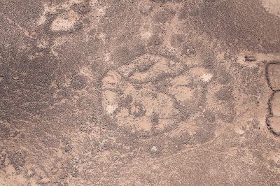
In the 1880s and 90s an intrepid British missionary called Willian Lethaby took up residence at Kerak in what is now west central Jordan. The indigenous population was mixed Muslim and Christian but fairly uniformly lawless, preying on each other and on any travellers passing by. Lethaby and his wife lived a hard life and suffered a great deal there from neighbours who often could be aggressive and even violent. Some of the burden of their efforts to proselytise and provide basic health care and education was shared when they were joined by Miss Mary Arnold. She appears in books of the time as a robust character and well-able to deal with the harsh neighbours and environment. One of the reports she sent back to Britain concerns a journey she made from Kerak to Jerusalem. In it she explains that because of feuding between beduin north of Kerak, she travelled south, down from the plateau to the valley south of the Dead Sea then north through Hebron to Jerusalem. The description makes it clear she was following the old Roman road known as the Zoar Ascent. This is the route I followed on the ‘walk’ organised by Prof. Haim Ben-David last year (blog post) and readers might like to read Mary Arnold’s account (see below). Of interest, too, is that when the missionaries were all forced to leave Kerak in 1894, it was said that she returned to her family in Western Australia. In the 1890s, the population of WA was small and the numbers who belonged to the Weslyan Methodist Church must have been tiny. A remarkable woman indeed.
DLK

LETTER FROM MISS ARNOLD extract from A. Forder (1902) With the Arabs in Tent and Town, an account of missionary work, life and experiences in Moab and Edom and the first missionary journey into Arabia from the north, 3rd ed., London, Marshall Brothers: 16-25.
"Jerusalem,
"August 15th, 1893.
"To Major General Haig,
"Dear Sir,
"Knowing you take such interest in all our movements and work both in and out of Kerak, I thought you would also be interested in my last journey from our mountain  home to the Holy City; and more especially so, as you yourself have also been over part of the road by which I came, viz:- through the Ghor Es-Safeah and Hebron.
"The road through Mojib and Medeba being just then closed on account of fighting between the Anazi and Beni Succor, we made arrangements for me to go with some Hebron merchants who trade between Kerak and Hebron. Not knowing them very well, we thought it wiser to take one Greek Christian man with whom I had travelled before. We were to have started at midnight on Friday, July 14th, but my man (Saleh) did not come for me until 3.30 a.m. Saturday. We were fairly off by 4 o'clock, and well out of Kerak by sunrise. We did not take the road you and Mrs. Lethaby took four years ago; but went due south through El-Mota and Khanazera, because, on their way to Kerak, these Hebron men had been attacked by robbers, and had one of their mules shot dead. They (our men) had only five guns (native made), and the robbers five Martini-Henri's. They kept up the firing on both sides for three hours; so no wonder they did not want to return by the same road.
"We reached Khanazera at noon or a little after, but did not stay, except to refill our water skins. But I must not forget to tell you that at El-Mota, where is an encampment of Keraki—the Seriri—I saw that poor ' Attowy ' boy Ede, who was in our school a short time; the one who lost his foot from a snake bite. He recognised me at once, and a broad smile spread over his black but intelligent face. With true Bedoui instinct, the poor child can't be happy for any length of time in a city, but longs for perfect freedom of tent life. I expect he will come back to us again some time. But to continue: our caravan consisted of twenty men, about forty donkeys and mules, one horse, and 500 sheep and goats. As it turned out, it was very foolish to try and take sheep through the Ghor in the middle of July.
"The first day  we did very well. Just after passing Khanazera, Saleh's mule began to kick, threw him off, and continued kicking, until there was nothing left on its back. Soon after this, we stopped for about half an hour to rest and take some refreshment. We made tea, and I was not the only one who was glad of a cup. This was just before the actual descent into the Ghor Es-Safeah began. We sat on one little green patch of ground, where was a little brackish water oozing out of the mountain side, and where there were thousands of hornets quite as thirsty as ourselves evidently. There were a few rank reeds growing, over which Saleh threw our abbas (cloaks), and made a little tent to shelter me from the sun. Soon the sheep caught us up, and on we went. We could not ride far, as the steep descent began. I rode until my mule fell down, when I managed to quietly slide off on to a big boulder of rock just near. After that, in mercy to the poor creature, I was obliged to walk. It was dreadfully hot, and I could not hold up a sunshade and scramble down these mountains, for the descent was worse than that of Mojib. But if it was trying to me, it was very much worse for the poor sheep and donkeys. The latter kept falling under their loads. After about four hours of this steep descent we came to a small table-land half way down, and the sun having set, we camped. We were too tired even to make tea; but after eating a little bread and chocolate and drinking a cup of goat's milk, I lay down on my lahaf (a quilt stuffed with sheep's wool) with saddlebags for a pillow not much softer than Jacob's stone—and tried to sleep; but, alas! the heat was too great. Not a breath of air was stirring. After twisting and turning about for some time I managed to get a few hours' sleep.
"By 3.30 the next morning, we were on the move again; and the air was delightful until the sun rose. I cannot pretend to describe the scenery. It was not beautiful or lovely, but grand and over-aweing. The rocks as a rule were of red sandstone, worn into all imaginable and sometimes weird shapes and forms by the action of sun and weather. I could almost talk to those grand old mountains. How sadly I wanted to ask them how long they had stood there alone in their solitary grandeur. In some places they were beautifully veined with a lighter or darker shade, and now and then one would suddenly find oneself at the foot of or entrance to some apparently fairy or ghostly castle or stronghold. Some rocks looked for all the world like immense tables with beautifully and delicately turned legs. I could but exclaim with David, 'Oh Lord! how wonderful are Thy works!' Could a human mind ever devise such awful grandeur as this, and yet such terrible solitude? Down, down, down! The Dead Sea looked so near, and yet we kept skirting round and round ever freshly appearing mountains.
"At last though, we really did reach the plain, and were immediately met by a dozen or so of half-dressed, black-looking Ghowarina. At once, when they saw me they said I was a 'Consul,' and were very much surprised to hear me say in Arabic that I was no Consul, but only a schoolmistress from Kerak. Here we re-mounted, and rode along with these well-mounted rag-bags (for the poor things were wretchedly clothed) for about another hour. All that hour they were trying to quarrel with our men (who would not quarrel), to take by force some of their loads. But our Sheikh, whose name was Abd-as-Salam (the Servant of Peace), joked with them, and told them he was not only of a peaceable name, but also of a peaceable mind, and did not intend to quarrel. They took one sheep and killed it, upon which our men made no comment. Then two or three of the raggedest of them rode up to me (they looked so ridiculous mounted on beautiful mares), and asked for 'baksheesh.' I said, 'From where, my brothers, should I have baksheesh, coming from Kerak?' at which they grinned and fell back.
" Here we came to fresh water, of which the poor animals had not tasted since leaving Khanazera. The stream was narrow and rapid. The poor sheep rushed headlong into it, and the others pushing on from behind, fifteen were washed away and drowned before the shepherds could get to them. About an hour after noon we came to the Ghowarina encampment where we found another Hebron merchant with a bush shed for his shop. He received us very kindly, and it was much cooler in his shed than in the tents. I was very tired, and I need not say, in a bath of perspiration. They put my lahaf down and in a very short lime brought us a bowl of beautiful grapes and some thin wafer bread baked on an iron pan over the fire. This, with a cup of tea afterwards, in which all joined, was very refreshing. Then I lay down, and covering my face with the muslin on my hat, in spite of the unbroken babel of voices, I slept. After about two hours, it suddenly occurred to my man to clear all the people out, in order that the 'Sitt' might sleep! Of course, the sudden cessation of noise awoke me.
"By 3.30 p.m. we were all up and off again. We made straight for the Dead Sea, about half way between the root of the Lesan and the southern coast. Here it was a great stretch of dry sand, with the exception of, at intervals, three streams of salt water running pretty swiftly from north to south; for at the south end we could see a considerable area of sea; and yet I should think dry land stretched some three or four miles on either side of us. First, however, we had to cross a stream I was going to say,—it was not water, but bog,—the nastiest filthiest stuff you could imagine. I drew in my mule until I saw how my fellows fared. The men caught hold of my animal's head, and proceeded — as I thought—to lead it through; but when they got ankle deep they threw the rope up to me, and let him go. Just at that moment, what lively and vivid visions I had of finding myself quietly landed in the middle of that bog! However, the men shouted, and I vigorously poked my mull and held on through all his flounderings, till we finally emerged safe and sound on the other bank. Some of the donkeys collapsed in the middle, and then the shouting and lifting and pulling were most vigorous. It was quite exciting to stand and watch them. The third and last stream of salt water we crossed was considerably above the mule's knees, and the western bank steep and slippery. Many of the donkeys slipped right back into the water; and it took some time to get them all across. But, the sheep and goats, poor things,—they were tired out, and the shepherds had to stand in a string across the stream, and pass them over from one to the other. Otherwise they would have been washed away, as it was deep for them and pretty swift.
"We got across the actual bed of the Dead Sea in a couple of hours and then cut straight inland. About 8 p.m. we had ascended to a small plateau, where we camped for our third night. During this day's journey about six or eight sheep and goats had died from the heat. One beautifully fat, full-grown sheep was done up and could not go on, so they killed it, and we had it for supper. It was piteous to look at several of the loaded animals, and one or two well-grown kids, which were fagged out. They lay over the load almost like dead things, now and then bleating faintly.
"I must tell you how they cooked our supper of mutton. First they built an oven of stones, and then lighted a fire inside. When the stones were very hot, they took away the fire, put the meat in and closed down the oven with stones and earth to keep the heat in. After about two hours of baking, the meat is done. As I did not want to wait for my supper and sleep to such a late hour, one of the men took the liver, kidneys, and sweetbread, and putting it on the ramrod of his gun, frizzled it over the fire for me. It was very nice. Here, too, we were able to get from a fountain about half-a-mile from our camping ground good cold water, which was a rare treat. A little of the water we had brought from the other side of the Ghor was left, and they were going to pour it away when I asked for it to wash my hands and face. They were so amused that I should think a wash in a cupful of water so precious, and more especially so at my soap, towel, and comb.
"During that day I had noticed that one of the young Hebron men, who had often been to us in Kerak for medicine, had his head tied up as they do for headache, and that he did not look well, so when we camped, I told my man to ask him if he would like some medicine. He was very grateful, and swallowed it down obediently. The next day he was very much better.
"By 2 a.m. (this was Tuesday) we were off again by starlight. In about an hour we came to a most remarkable defile called the Wady In-Nakhbar. It was so narrow at first—and for some time—that we could only go in single file. The cliffs rose up sheer on either side to a height of, I should think, from 100 to 200 feet, white like chalk. In many places we could scarcely hear the tread of the animals—it might have been a caravan of camels, for the noiseless way in which we plodded along and by starlight. In other places the ground sounded hollow and unreal Just at sunrise we had descended again to the level of the sea, within a short distance of Jebel Usdum; but instead of going between it and the sea we turned sharp off up to the 'Zewire-el- foke,' right away up to Masada. There the ruins are most remarkable, as you know, rising up so sheer from the top of that little mountain, and commanding the whole of the valley right down to the Dead Sea. There we camped for the three hottest hours of the day. The water there is simply what is caught in the rains. While the men were down below filling the skins, and we were waiting for them with as much patience as thirst and heat under the noonday sun would allow, I tried to sleep a little, but it was too hot.
"By noon we were off again. In a couple of hours or so, we reached some very good water-springs, an hour or an hour and a half south of Hebron, after passing through Karmel and Ziph. Here we unloaded, had a good drink, made some 'damper,' ate, drank again, loaded up, and jogged on to Hebron, which we reached about 5.30 p.m. Abd es-Salam took me straight to his house in the heart of the city (near to the Cave of Machpelah), where I slept. They of course were Moslems, but exceedingly kind, and gave me a beautifully clean, native bed on the floor. Next morning I did not wake until late, and as soon as possible, asked Abd es-Salam to let his son go with me to Mr. and Mrs. Murray's house. This he did, and no sooner did Mr. and Mrs. Murray know who I was than they received me like their own sister, and would insist upon getting breakfast for me and keeping me there. In the afternoon we all went up together to the Mildmay ladies. There, too, all were very kind. That night I slept at Mrs. Murray's. Oh, how refreshing it is to meet and hold converse with such holy children of our Master! Mrs. Murray was a great blessing to my soul. Their presence in Hebron ought to be more widely known, as they are entirely dependent upon what their Heavenly Father sends them. Truly God chooses the weak things of this world to confound the wise.
"The next day (Thursday) I stayed with the Mildmay ladies until 10 p.m., when once again my men came for me, as we had arranged to ride on to Jerusalem in the night for the sake of coolness. This we did, reaching Jerusalem at sunrise, Friday morning; and Mrs. Reardon's Welcome Home of Rest at 5.30 a.m., Friday, the 21st of July.
Sincerely yours,
Mary Arnold.

Research: Emily Beke's description of a 'Kite'

$
0
0
Our research into 19th century travellers' accounts of Syria and Transjordan, and more specifically what they encountered in the 'Hinterland of Roman Philadelphia' continues. Every now and then we turn up something fantastic, but not necessarily on our current topic of research.
Portrait of Emily and her husband Charles Tilstone Beke photographed by Ernest Edwards (Lovell Reece, 1867, 'Dr. and Mrs. Beke', in Portraits of Men of Eminence, Vol. 6, London: L. Reeve & Co.: 21. Original in the Natural History Museum, London: 051942).
Recently, we found a description of the function of a kite by Mrs Emily Alston Beke, wife of Charles Tilstone Beke. She wrote the following:
"It is curious how these animals are caught by the Beduins in the desert country lying to the east of Harran. Two walls of considerable length are erected, commencing at some distance from each other, and converging to a point. Before the two ends quite meet, a mound of earth is thrown up between them, and the two walls, being continued beyond this mound, are united by a cross-wall of about half their height; behind this lower wall is a large pit, the earth dug out of which had served to form the mound. Horsemen now contrive to drive a herd of gazelles between the two walls, where they are furthest apart. The timid animals rush forward towards the extremity of the enclosure, at first not seeing the low cross-wall, which is hidden by the mound of earth; and when, at length, they find themselves closed in on both sides, they naturally try to escape by ascending the mound and leaping over the low wall, when they fall into the pit beyond it, and are taken, often as many as twenty or thirty at a time."

The entry is dated Tuesday December 24th, 1861 when Emily and her husband were visiting a Dr. Wetzstein in Damascus where they were sampling wine made from Helbon/Halbon grapes. The description must be that of a Kite. The description is particularly useful as what we currently know about the function of a kite is almost entirely derived from their remains and some inscriptions, whereas here we seem to have a contemporary account of their use, and what's more, it implies that Kites were still being used to trap gazelle into the 19th century. The area she refers to 'in the desert country lying to the east of Harran' is the northern tip of the Harrat ash-Sham east of Harran al 'Awamid. A large group of kites are located in this area, beginning roughly 15 km east of Harran al 'Awamid (or 40km east of Damascus), which we have located using satellite imagery freely available through Google Earth and Bing Maps. These kites were first photographed by Poidebard - one is published in La Trace de Rome (1934: Pl. XIV) (see Bewley & Kennedy, 2012, 'Historical Aerial Imagery in Jordan and the Wider Middle East', in Hanson & Oltean (Eds), Archaeology from Historical Aerial and Satellite Archives: Fig. 13.2 p. 226).

In exploring Harran in pursuit of a theory about an Old Testament place name, the Bekes discovered an inscribed stone (p. 199 ff.) which was later identified as a Roman milestone (p. 124ff.). Another was later found in a neighbouring village the name of which Emily gives as Ghassule (p. 125). Very unexpected.

Emily was 37 years younger than her husband but a fitting companion and his equal in many respects. Her published diary, and notes in the archival material of her husband show that she is highly intelligent, independent and active woman- accompanying her husband on at least one journey, helping him in his academic pursuits and publications as well as running their household as smoothly as she could with the expenses from research tours and publishing. After her husband's death she remained a staunch advocate for his lifetimes work, continuing to publish his research at considerable cost to her financial position.

Research: More on the Bekes (Beeks)

$
0
0
Emily and Charles Beke were early travellers in what is now Jordan. Emily was a particularly notable traveller simply as that rarity amongst western travellers up to that point – a woman. But even in 1862 she was not the first known western women to travel in Jordan – Charlotte Rowley had visited Petra with her husband and a friend in 1836 and Mary Ann Roberton Blaine was in northewestern Jordan with her husband in 1849.

The Beke family had also had a member in the region before Charles and Emily. In 1839 Charles’ younger brother, William Beek (he kept the old spelling of the family name), an engineer in The East India Company had worked with the Irishman, George Moore around the Dead Sea ('On the Dead Sea and Some Positions in Syria', JRGS 7 (1837): 456). Various hints point to William having also been to Petra and Jarash at least. William is an interesting character in his own right. A few years earlier he had apparently served as an adventurer in the army of the Persian Crown Prince, Abbas Mirza. It was reported that ‘he led a siege and an escapade against a Turkoman fortress in Khorasan’, in what is now Turkmenistan.

William later appears in Sicily and Italy apparently managing mining operations. An infant son died there as a gravestone from the English Cemetery at Messina in Sicily records:
“William James Beek born 1st December and died 25th June 1840, the son of Ann and William George Beek”.

Another son – Charley, survived to work alongside his father until the 1870s at least and a further son – Reginald Maitland Beek, married a girl in Queensland in September 1888.

A fascinating family and deserving of further investigation, not least for their activities ‘east of Jordan’.
DLK

Archive: Ground photographs

$
0
0
If you follow our Flickr archive you will have noticed we have been uploading a large amount of ground photographs over the last couple of days. What, you may ask, is an AERIAL photographic archive doing uploading so many ground photographs?

Well, in short, you cannot make sound conclusions from the aerial photographs unless you go and have a look on the ground – and this is why we have conducted so many ground visits. Additional information can easily be gathered without the need to conduct any formal excavation – such as if stone is worked or not, if there are large amounts of pottery scattered over the site, and whether there are any associated structures not easily visible from the air such as wine presses, cisterns etc.

This means that on our Flickr photostream you may compare the impression you get from a site as seen from the air with how that site appears on the ground. Ground photographs reference numbers are prefixed by APAAMEG (Or you can find them all in the collection here).

Something you may have noticed is that we are continually returning to sites. We revisit sites that are at particular risk or are constantly changing – such as Yajuz and the risks associated with the urban development of Amman, or the ongoing excavation, conservation and restoration projects at Jerash. A good excuse to visit sites again is when the team has a new member.

Something new to our Flickr archive and still being trialled with this most recent upload of ground images is the inclusion of ‘Pleiades’ tags. Pleiades (http://pleiades.stoa.org/) is an open source project developed by the Ancient World Mapping Centre, the Stoa Consortium and the Institute of the Ancient World. The database of sites is developed to act as a continually updated referenced atlas of the ancient world. They list 34,690 places and counting.

Each site has a unique identifier which you use to complete a ‘machine tag’: “Pleiades:depicts=******” if the site is depicted in the photograph, or “Pleaides:atteststo=*****” if the object photographed attests to the existence or location of the site- such as an inscription. There are other combinations too which you can read about on Sean Gillies blog.

By using these tags the Pleiades database recognises that we have photographs of their documented sites, and therefore people accessing their database of sites can easily access our photographs that relate to that site. Everyone ends up a winner! If you have feedback, please don’t forget to let us know.

If you are interested in the Pleiades project, or wish to become a contributor, please visit their website for more info.

Research: Harrat Khaybar

$
0
0
For quite some time now I have been working on a large group of kites we found in a high resolution window in Google Earth around the ancient oasis and site of Khaybar. The huge concentration of kites fascinated us, so we have been conducting a comprehensive study and gathering data on the kites. This has included taking measurements, mapping, drawing and creating typologies.

While I have been working away I have constantly been struck by the ‘grass is always greener’ mentality, and wondered what lay behind the fuzzy pixels of the lower resolution imagery around my high resolution window in Google Earth. Well, that was answered for me today by Bing maps. My window has been completely blown open, and though for brevity and time’s sake I shall no doubt have to limit my study to the original window in Google Earth, the additional information provided by the larger context is incredibly helpful.

Firstly, I can confirm my suspicions of patterns:– the amazing series of kites that almost appear strung together by their tails that are located to the east of Khaybar have sister strings to the south of the high resolution window.
A string of Kites from east of Khaybar (drawn: Rebecca Banks).
Secondly, a report with accompanying photography by M. John Roobol and Victor E. Camp in their ‘Explanatory Notes to the Geologic Map of the Cenozoic Lava Fields of Harrats Khaybar, Ithnayn, and Kura, Kingdom of Saudi Arabia’ (1991) that showed what appeared to be a Kite stratified underneath a tongue of Pahoehoe lava of the Habir flow could be identified in the satellite imagery. The area reveals at least one Kite partly overlain by the lava flow – and several other stone structures as well. The Habir flow is ‘historic’ but the exact date is unknown – the eruption date could be anything between the 1st century AD and 1800 (Roobol & Camp: 23).

Guest blog: Włodzimierz Rączkowski Qatar Workshop

$
0
0
You may remember earlier this year we conducted an aerial photography workshop at the new UCL Qatar campus with Włodzimierz 'Wlodek' Rączkowski (see DLK's blog here). Wlodek has been kind enough to contribute the following comments, which have now found their way to our blog.

A White Easter! No, that's not a mistake – if you had spent Easter in Poland this year you too would have thought a Christmas tree more suitable and looked for Santa rather than the first spring flowers and chocolate eggs. So this Easter-winter lead me to think about my visit to Qatar back in February. The flowers were blooming and the weather conditions were much more spring-like. A different world altogether.
Why Qatar? It came as quite a surprise. Bob Bewley (UK) and David Kennedy (Australia) together with Lisa Usman from UCL Qatar undertook the initiative to organise a “short course” on aerial archaeology (10-14 February). An exotic subject in an exotic country and I got to go along by chance as a tutor/lecturer. You can read more about the workshops themselves in AARGnews vol. 46 (March 2013), p. 15-18 – The AARG website can be found HERE.

Everything in Qatar was amazing, new, different, unexpected – including the workshop timetable. Is it possible to fit in a bit of rest and relaxation and sightseeing halfway through a series of workshops? Actually yes, it is – for it turned out that Tuesday (12th February) was National Sport Day, a surprise for both the organisers and lecturers. A double surprise in fact – a day of sporting events at a national level (less surprising when you recall that Qatar is due to hold the Football World Cup in 2022 and when you spot the joggers in all their gear along Doha's Corniche or main boulevard) and a public holiday so that everyone can “do a bit of sport”. Well, how to make the most of such a gift?

Qatar isn't a large country but then not all the sights to see are located in Doha. I persuaded Bob and David to take a trip south to Khor Al-Adaid, also known as the “Inland Sea”. It's a large tidal inlet with a convoluted shoreline cutting deeply into the land dividing Qatar from Saudi Arabia. It is connected to the Gulf by a deep, narrow channel. There is no comparable lagoon system of this type known anywhere else in the world. It is a UNESCO nature reserve (see: http://whc.unesco.org/en/tentativelists/5317/ ). A large system of barchans and parabolic dunes covers flat areas of former marine sediments creating a unique landscape. For those of us from the northern hemisphere (Bob and myself), the yellow sand, turquoise water and blue sky set the perfect scene for a bit of relaxation.

The Inland Sea is not particularly easy to get to. There are no roads leading to it but kilometres of sand dunes to cross. The only option was to hire a car and Bob, after having made a number of phone calls, managed to acquire a 4WD Nissan XTERRA – the best choice of vehicle for a trip across Qatar; ideal that is if one has all the additional equipment (spade, ropes, lots of water) and experience of driving over dunes. It turned out that we had the car... and nothing but the car.

As we approached Masaieed (only about 40 km from Doha) the first impressive dunes could be seen. After that there were no roads or signs to follow, only a general direction of SSW and the tyre tracks of other cars to indicate where we should be going. So when the tracks forked off into two directions, what were we to do? Was this our intended destination? There we were, driving “in the dark” at high noon in a land flooded in sunlight and sand. It was quite busy near Masaieed as there were many places to hire quad-bikes and go scrambling over the dunes. The further S we went, the more deserted it got: fewer people, cars, signs of civilisation. We encountered the odd car or two sporadically (did they know the way better than us? - not too unreasonable an assumption).

After about 2 hours driving, without great misadventure, we made it to our destination – the Inland Sea. Good job we didn't decide to drive up to the waterline (though it was rather tempting) – the sand was really slushy and it was hard to get up to the water's edge even on foot.

And what do Europeans do when they find themselves by the sea, surrounded by sand and blue skies overhead? That's right, they head out for a paddle – and... what a disappointment that was. The temperature of the water was more like the Baltic in the summer (about 17-18 degrees). Brrrrrr! Just a quick dip then.

The suggestion to climb up the nearest dune was outvoted 2:1, so it was time to get ready to head back. One question which arose quite quickly was: do we have enough fuel? Apart from this one concern the journey back went smoothly – up to a point. At 14:02:15 (according to our SatNav) we got stuck in a dune which caught us unawares for this dune was nothing special, just a bit of loose sand. We'd managed to scale much larger dunes before! It turns out that “reading this sandy landscape” is in fact quite an important skill.

So what now – it's no use having a great 4WD drive if you don't have either a spade or ropes. A couple of attempts to move forward/back and... we were chassis-deep in the sand. A few cars drove past but not one stopped, hardly surprising as they were probably tourists. Fortunately for us a “local” spotted us and realising that we were in trouble he offered to help. The first manoeuvres (reversing, letting some air out of the tyres) were unsuccessful. Time for the rope. Luckily, our local hero did have one and easily towed us out of the sand trap. The rest of the journey was uneventful, we did have enough fuel. We had all been so intent on getting out of the sand that not one of us thought to take a photo (photography specialists that we are!).
Extensive stone structures in the shallows near Abu Dhulouf.
And so back to the photography then. When I was travelling around Qatar I thought about the usefulness of aerial photographs in this country, especially in documenting archaeological heritage. I did not see too many opportunities. At least not until after the workshops when I went north to the area around Abu Dhulouf. It was low tide, so there was no chance of swimming but it was possible to go wading ankle-deep in water across the sandy expanse. I observed extensive stones structures – low walls stretching for kilometres. It was impossible to capture their spatial structure. I imagine they were fish-traps, or perhaps an area for hunting birds. I have no doubt that aerial photographs would be the perfect method for documentation and mapping. Shortly after take-off from Doha I noticed a similar though smaller stone structure. There's my reason to return!

Seminar: David Kennedy. “Al-Muwaqqar. Salvaging an Umayyad Desert Castle and its Context”

$
0
0
On our recent fieldwork in Jordan in April we paid particular attention to the Umayyad site of al-Muwaqqar on the fringe of the steppe east of Amman (see our blog entry: Flight 20130414, Field Trip 20130416 - al-Muwaqqar). Our interest has only increased with subsequent detailed examination of previous travellers’ and archaeologists’ reports, photographs and drawings of the site – the first date to the late 19th century include John Gray Hill and his wife Caroline, Rudolf-Ernst Brünnow and Alois Musil. Later accounts include the better-known publications on the distinctive capitals by R. W. Hamilton, and K. A. C. Creswell, author of Early Islamic Architecture (1969) as well as the lesser-known excavation reports published in the Jordan Department of Antiquities Journal, ADAJ. In addition to this there are historical aerial photographs of 1939 and 1948, and our own photographs of the site dating 1998-2013. Piecing together these accounts with the surviving visible record has led to an impressive picture of a complex Umayyad site comprising of at least 2 reservoirs, c. 90 cisterns, a large Qasr or palatial residence, a second structure of unknown function, and what may be an associated bath-house with mosaics.

A brief summation of our investigations were presented today at St. John’s College, Oxford at one of the weekly ‘Late Antique and Byzantine Archaeology and Art’ Seminars. The lecture was well attended. Positive and informative feedback from peers was most welcome and has given us much food for thought. The resulting publication on this topic is in the works: watch this space.
David Kennedy presents in the New Seminar room at St. John's College, Oxford.

The Online Corpus of the Inscriptions of Ancient North Arabia

$
0
0
Inscription in the vicinity of the Cairn of Hani, Jordan. Photograph: David L. Kennedy, APAAMEG_20091014_DLK-0017.
This week APAAME has made over 200 ground photographs available to the Online Corpus of the Inscriptions of Ancient North Arabia (formerly the Safaitic Database Online) for inclusion in their database. The photographs were originally taken during follow up ground visits to sites after they had been photographed from the air. The majority of the photographs were taken in the 'Black Desert' or Harret al-Shaam in Jordan and many of the inscriptions were associated with features we were interested in, such as Wheels, Pendants and Cairns. As the APAAME team are not experts in Safaitic or Hismaic, let alone Dadanitic or Taymanitic, we are enthusiastic that these photographs will be made available in a database designed for their study.

For more information on the inscription database please see the passage below made available to us from the project, or visit the project website HERE.

If you wish to see some of the many photographs of inscriptions we have taken, please visit our Flickr site where we have tagged the majority with 'inscription': http://www.flickr.com/photos/apaame/tags/inscription/.

OCIANA (Online Corpus of the Inscriptions of Ancient North Arabia)

From the early first millennium BC to around the fourth century AD, literacy was extremely widespread among both the settled and nomadic populations of the Arabian Peninsula and they have left us tens of thousands of inscriptions and graffiti. Since the late nineteenth century, approximately 48,000 of these have been recorded by travellers and scholars and have appeared in hundreds of articles, books, and unpublished dissertations in a number of different languages. This makes it extremely difficult for all but a handful of specialists to keep track of and use the rich material they contain. Moreover, any visit to the deserts of southern Syria, eastern and southern Jordan and the western two-thirds of Saudi Arabia reveals that there are thousands more inscriptions waiting to be recorded.

The OCIANA project, is based at the Khalili Research Centre, Oriental Institute, University of Oxford, and directed by Professor Jeremy Johns and Michael Macdonald. It will create an online Corpus of all the pre-Islamic inscriptions of north and central Arabia, both those in the various Ancient North Arabian dialects and scripts, and those in Old (i.e. pre-Islamic) Arabic. A project at the University of Pisa (the Digital Archive for the Study of pre-Islamic Arabian Inscriptions, DASI) is producing an online corpus of the inscriptions of pre-Islamic South Arabia, and the two projects are working closely together so that it will be possible to search the information in both corpora through the same portal.

In 2012, the first phase of OCIANA, funded by a grant from the John Fell Fund at the University of Oxford, launched a demonstration site in which a corpus of 3420 previously unpublished Safaitic inscriptions was made available online with readings, translations, commentaries, ancillary information, tracings, and photographs (see http://www.ociana.org.uk). In January 2013, the project received a large grant from the AHRC for Phase II which will last three and a half years from 1st October 2013. In this phase, the Dadanitic, Taymanitic, the rest of the Safaitic, Hismaic, and Old Arabic inscriptions will be entered and tagged, with all available ancillary information and with photographs whenever these are available. Phase III will see the entry of all the approximately 13,000 Thamudic inscriptions.

Flick Archive: Search issues

$
0
0
Users of our archive hosted on Flickr may have noticed that the interface has gone through some changes recently. Unfortunately this has included what seems a serious glitch in the search tool- basically that you may not get any results at all even if a photograph is named exactly with what you search for (such as 'Umm es-Surab' as I recently found).

My basic experimentation with the problem indicates that a search will find items 'tagged' with the search terms, but not if they are named with that term. If you are having trouble finding a site as a temporary solution I advise that people search for photographs of their site using the georeferenced search tool at www.flickr.com/apaame/map
You can find instructions on how to do this on our YouTube channel: http://youtu.be/rFEF4Vjdo00
If you still have difficulty finding your site, please contact us directly.

Thank you for your patience as we adjust the archive to the changes occurring on the Flickr interface.
Viewing all 125 articles
Browse latest View live